So I have finished finally detailing Threshold. Right now I just have the basic details filled in; the only people with names are those mentioned in canon sources, so most of the town is just Farmer and wife, or Innkeeper, etc. I am not going to make an actual map of the town yet, first I want to map the first 3 levels of a megadungeon under the town. I also am going to continue my thoughts from
here and work on a series of posts exploring the purposes of a map in an RPG and how to effectively map urban areas. After I know exactly what I want from a town map I will come back to Threshold. Below I have provided a few screenshots of different ways to look at the town based on the current data.
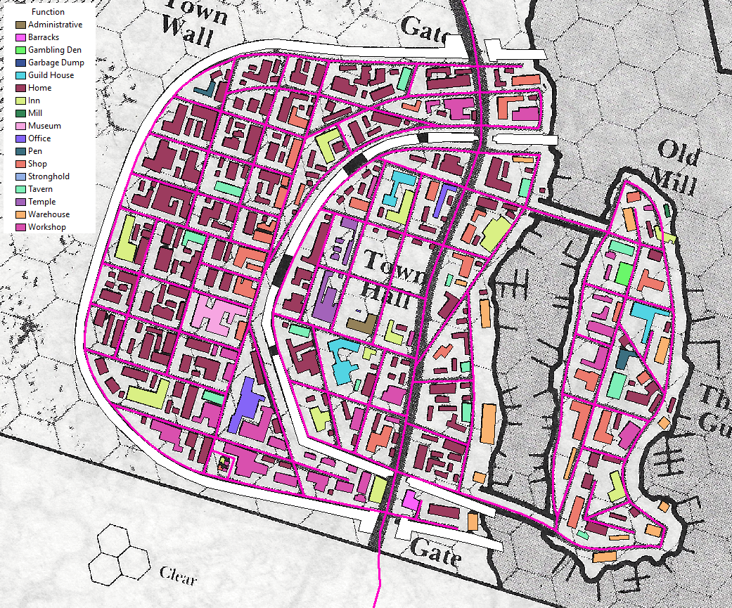
 |
| Displays what each building is used for; majority of the new town is homes, significant number of inns and taverns scattered throughout the town, most workshops centered near southern wall, and concentration of shops along a single street in new town have given it the name of merchant street. |
 |
| Different guilds of the town; merchants appear to be most numerous, thieves have extended control of island, and the hostliers also are a large guild given the number of Inns and Taverns |
 |
| Distribution of population in the town, seems to be fairly random, I was hoping the population would be denser on the island |
 |
| A sort of Height map of the city, the island and the inner town definitely have taller buildings |
 |
| Materials of buildings, most of the stone buildings are old and left over from earlier settlements, this is also true of many of the mixed stone and wood building, and original stone building or the ruins of one were expanded with wooden structures. Brick is a newer source of building material, hence its rarity. Most of the town is made of wood because of the easy supply available from the nearby forests and Threshold is a center for shipment of lumber downstream. |
Now that I know what is where in Threshold I can begin to design the megadungeon. My idea for it is this: underneath the town are ruins of an older city, and parts of it remain as cellars of some of the old buildings or buried just under the surface, so there are these disconnected buildings beneath the current town, and some of them have surviving connections to an old sewer or canal system below the ruins. The ruined buildings will act as the 1st level of the megadungeon, and the sewer system will be the 2nd level. From the the second level there will be a few select passages to the 3rd level, which will be a classic maze-like megadungeon. I also have a few ideas for lower levels, and I am thinking of connecting the lower levels to caves in the hills nearby inhabited by humanoid tribes.
Areas mentioned or detailed beneath Threshold in canon sources are caves and canal beneath the juggling ogre from Trouble in Threshold, a dungeon beneath the old mill from the Expert set, a maze of tunnels made by Purple worms from the Expert set, the cellar under the Crossed Swords tavern leads to old sewers from Night's Dark Terror, and the possibility of old Traladaran/Hutakkan ruins of Lugsid or Zadreth from Hail the Heroes. Other areas I want to detail for the 1st level of the dungeon include ruins of an old villa under the adventurers guildhouse which I have already made a basic layout for, and catacombs under the churchyard.


From the Google+ group Mystara & the Known World
ReplyDeleteLance Duncan:
Beginning my work on a megadungeon in Threshold
Jay Murphy:
That is awesome. Will you continue with this on MeWe?
Lance Duncan:
I'm not sure yet, I've looked at MeWe, but I'm don't know if I want to switch over. The only reason I've been sharing to Google+ is because it's connected to Blogger and there was already a large RPG community here.
From the Google+ group Map-Making in Games
ReplyDeleteLance Duncan:
Initial workings on a map for Threshold from the world of Mystara
Keith J Davies:
A suggestion, very few walled cities had everything inside the walls as cleanly as this one. At the least I would expect buildings along the road and shoreline.
Lance Duncan:
this is due to my source material, this is the map from a D&D rulebook. If it were up to me the town would be much smaller, it is supposed to have only 550 residents and there are about 350 buildings. If I were to make it from scratch I would put everything on the island.
Keith J Davies:
Well, if you have to fit the original source, it's the original source's fault :)
Jim Alcala Sales:
Reminds me of Zhentil keep.
Lance Duncan:
you're right, I just looked it up, and they are strikingly similar. I have seen Zhentil keep before, but just forgotten about it since I don't really play in Forgotten Realms.
Scott Anderson:
ReplyDeleteWhat program did you use to do the various maps?
Lance Duncan:
Currently I'm using ArcGIS, but my license will be ending soon, and I'll switch over to QGIS. I have been saving all my files in a format compatible with both GIS programs.
what you see here is just really basic rough versions to show the data without me putting any effort into making the maps look good.
Scott Anderson:
+Lance Duncan I know what a GIS is but I had no idea you could use it on imaginary places!
Lance Duncan:
+Scott Anderson lol, of course you can. You can use adobe Illustrator, or MS Paint on imaginary places right? same thing. they are just fancy software programs.